Pages

Pages

Showing posts with label ASI. Show all posts

Tuesday, 25 February 2020

A Walk along the Northern Ridge with Prof. Sanjyukta Datta


The First Heritage walk by the History society for the year took place on 1st February, 2020. Saturday had about 10 of us had accompanying Prof. Sanjyukta Datta in and around the Northern Ridge, visiting various monuments of the region. We had just entered the ridge area through the gate opposite Delhi University at around 11 in the morning and were looking forward to the day ahead.  As we approached the Flagstaff tower, our first stop of the day, Professor Datta informed us that the local Archaeological Survey of India (ASI) team was waiting for us.
The Flagstaff tower was built in the early 19th century and was used to hoist the British flag all the way up to 1947, said Professor Datta. This was where women and children hid during May 1857 when the Meerut rebels/mutineers had taken the city. They later fled from there to Ambala.
The ASI officials allowed us access into the structure. The inside is a single circular room with a spiral staircase in the centre, leading to a first-floor balcony, and finally a terrace on top with a 360 degree view.
Taking some group photos here, we walked down the path to a guardhouse, from the Tughlaq era.
The Southern guardhouse

The ridge has two major groups of monuments: Those from the Tughlaq era, and those connected to 1857 in some way. The guardhouse was a Tughlaq era monument, from when the ridge was Firoz Sha Tughlaq’s hunting grounds, and he had a hunting lodge here (evidence of which survives).
The guardhouse does not leave us with too many clues to the past, and we soon moved on to the Chauburji. This structure takes its name from the four domes that had adorned it in the past, only one of which currently survives. It has a large open area on the ground floor, and the first floor is an open-to-sky mosque with a large platform in the centre. One of the domes is in the corner of the terrace. In the last few years ASI has managed to restore what is left of the structure. Again, thanks to our ASI friends we were allowed to go in and explore.
The mosque on top of the structure has faded inscriptions around the doorway and the motifs have deteriorated over time, but the overall charm remains. Professor Datta pulled out a book on the 1857 events in Delhi, and showed us the photo of the Chauburji from soon after that. It looked quite different from the photo there, with half the building missing, and the structure was quite different. We decided to see if we could identify which part of that mosque coincided with the existing structure. After some effort, we were able to piece together which part corresponded to which, through inference. Here the ASI officials took their leave and we headed on.

We then left the ridge and headed to Pir Ghaib, that combined both eras of monuments; a Tughlaq tower that contained the myth of a 19th century disappearing Djinn, passing the sign to Hindu Rao Civil Hospital on the way.
Hindu Rao was a Marathi and brother-in-law to the Scindias of Nagpur, who had broken away and moved to Delhi. In 1835, William Frazer, a British official, was murdered, and his house on the ridge was acquired by Hindu Rao. The house acted as the headquarters to the British on the ridge in 1857, and later became a hospital (we passed the building a couple of stops later, and the current structure bears little to no resemblance to the early 19th century one).  

Pir Ghaib sits in the middle of modern residences, and looks completely out of place, yet comfortable in its unfamiliarity, like old furniture in a fancy new apartment. The structure was purportedly built in the time of Firoz Sha Tughlaq, again, a part of his lodge, and was perhaps an observatory, due to the holes built into the ceiling.
Pir Ghaib

From here we passed a Baoli, or stepwell of around the same time period, and passing Hindu Rao Civil Hospital (which I had mentioned earlier), in whose vicinity Timur, the Turkic warlord, is said to have pitched his tent when in Hindustan, we arrived at the Ashoka pillar.
Erected by Ashoka in Meerut, this was one of two pillars brought to the Delhi region by Firoz Shah Tughlaq. It contains a series of lines in Brahmi from the time of Ashoka, with a shorter, later inscription below. It was said to have been blown up around the middle of the 1710’s, and was later put back together and deciphered by the British in the 19th century.  After admiring this round rock shaped by a human 2300 odd years ago from all sides, it was time to move to the last stop of the day, the mutiny memorial.
The Ashoka pillar

This was the most modern monument of our walk as well. Built in the 1860’s, it provides a timeline of events for the British recapture of Delhi, as well as acting as a memorial to those who died on the British side during 1857. Later some of us opined that if we hadn’t known better, it could have looked like a church from a distance.(For more on the Mutiny memorial click here) Built at a height, it dominates the surroundings. This was also the area the British set up camp during their retake of the city.
With the walk now over, we all headed our separate ways. Most of us headed back to campus. It took a while for us to realise that the walk had been so long, we had missed lunch. But it didn’t matter. The walk had more than made up for it.  

Flagstaff tower

The path up the ridge as seen from the flagstaff tower


Chauburji

The crumbling mosque atop the Chauburji

The signpost to Hindu Rao Civil Hospital(now much further away)


Hole in the ceiling, possibly for Astronomy at Pir Ghaib


Ashoka pillar

The plaque at the base

Mutiny Memorial 


Locations: 


Hindu Rao signpost (rough location, next to the garbage dump)


This article first appeared in The Edict magazine of Ashoka University, it has been slightly modified for this blog

Friday, 5 October 2018

Mutiny memorial: An 1857 monument in Delhi.

It was a strange day, particularly because the weather was pleasant. And it was Delhi.
Of course, this meant it had to be taken advantage of, so my mother and I set off to see the historic sites of the ridge.`
The ridge is a geographical feature to the North West of Delhi. During the seige of Delhi by the British in 1857, they had set up camp on this ridge. Later, a memorial, known as mutiny memorial was built on it, and a little later, it was declared a protected forest area. Known now as the Kamala Nehru ridge, it houses an observatory, army guard houses, a walking track, the mutiny memorial - and an Ashoka pillar(brought there by Feroz Tuglaq).
Stretching from Lala Hardev Sahai Marg, all the way past the Legislative Assembly complex, to the highway on the other side, and the North campus of Delhi university,with the Dr Karnwal road running through it, it encompasses many acres, it provides much needed green cover to the capital. (which has always shocked me with how green it is, in comparison to many other cities in the country. )

Taking the metro, we got off at Pulbangash metro station, and walked across the road, into the ridge.
The moment you step onto Dr Karnwal road, the drop in temperature is visible, as the road begins to slope upward. Rising up, it goes past a park, and all the way as far as the eye can see, with trees hanging overhead all around. 
As we walked, a Gothic spire suddenly rose out of the trees in the distance. As we got closer, we realised what it was - the mutiny memorial. 
The gate was closed, but a security guard came and opened it for us. Rising up, about 34 metres high, stood the memorial.
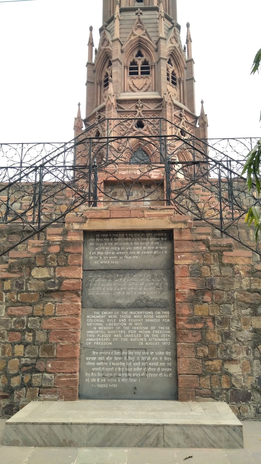
Right at the base, was a board, set up by the ASI, detailing the structure and history of the memorial.
This was where Taylors battery was situated, during the seige, at that very site, it says, and the pillar built in 1863.
 At the base of the turret itself was a plaque put up by the Government of India in 1972, as way of explanation in 4 languages, Hindi, . Its walls bore record of all the casualities the British sustained, European as well as Indian, and a message in four languages: English, Hindi, Urdu and Punjabi, commemorating their victory as well as mourning their losses.
Location: Mutiny memorial

The mutiny memorial


The locked door leading into the turret


The security guard and a dog


We looked around for a while, as friendly dogs lazed around, enjoying a rare pleasant afternoon. 
As we were about to leave, we asked the guard about the Ashoka pillar. He confirmed that it was there, but he said the gate was always locked - but if we wanted, he would come with us, and we could jump over the gate. My mother was in no mood for such tricks, and we returned to Pulbangash, to go back to where we were staying.

Saturday, 29 September 2018

Trip around the Palar: June 2017

A trip around the Palar:
 A group of us went for a trip to the area around the Palar: Melpadi, Arcot, Thiruvalam and Tirumalai.
6, on a Sunday morning, when only the birds, the trees and the heritage enthusiasts are awake.
That same 6am brought me to the trip conducted by Mohan Hariharan, as a sequel to his Arani trip from March, which I missed because of my board exams.(However, I caught a repeat in 2018.)
Venkatesh Ramakrishnan told me about this trip, and I very eagerly said 'in'. I was not disappointed.
As i approached the meeting point, the Saidapet bus stop, only 2 others were there.
I informed them that as there were still 15 minutes left for 6, I would go have a look at the Petrus Uscaan stone, near the Saidapet bridge, erected 1726.
By the time I returned, people had begun to arrive. Now this trip had 3 DSLR's and an iphone. Promises of a photographic expedition.
There was time enough, and a world of heritage to see right there, and as the van was delayed, we took a walk down to the teachers training college, but it took longer than we expected.
We had had to go around the Metro work to go down a small muddy side road with garbage trucks and cement lorries parked on it, so it took time.
Image may contain: plant and outdoor
The Uskan stone in 2017. It is now better kept, and part of the metro's fence.

Image may contain: tree, sky, plant and outdoor


 Just on time, we reached the main road, and got into the bus.We each took a seat where we could find it.
A short ride later we were at Guindy,

 Stop 1: Melpadi:
The Melpadi temple is of the Chola era, a Nataraja temple,  and would have been built before Rajaraja's time. it is built completely in stone. The sculptures are of different eras, but the kalvettus are all Chola.

At the metal gate that proclaimed that the ASI maintained the temple we went in full force, cameras blazing. But as soon as we reached the stone gateway, an even stonier faced watchman greeted us, saying no photos.
 Apparently ASI has a policy of no photography at any of their sites.
We finally got it out of him that only cameras are not allowed for use, and phone photos are OK. But he was not happy about letting any photos be taken.
The temple opens into a passageway that leads into a mandapam, and a raised pathway around a garden surrounding the main madapam.
The inner prakaram has thousands of lines, one mentioning the pallipadai of a Chola ruler, probably Arinjaya's which is down the road.
We went around the temple, inside and outside, and I noticed something very curious outside. A line of stone pillars lined up along an outside passage. Each in a different state of breakage.

One of the side mandapams, had a side room which held the old samayal arai. The centre of the room had a well, square in shape, going down many feet. Next to it were two stone semi circles, which held water. Around the well was a gallows like structure, which definitely had a different use.
There were no other visitors, and the temple was silent and serene.
In front of the complex, we noticed, as we left, was a hero stone. This hero held a spear and shield, so probably led an attack, or defence, against local bandits, or a rebellion. This region was the northern region of the Chola empire from the time of Arinjeyar (grandfather to Rajaraja, father of Paranthaka. This region was always under turmoil, and near this spot was the Takkolam battlefield, where Rajaditya, eldest son of Parantaka, died, fighting the Rashtrakutas.His fathers Pallipadai lies down the road from the temple, which is where we went next.

After looking around this serene, well maintained temple, we walked down to Parantaka's pallipadai.
What is a pallipadai? It is a Lingam, buried in the ground, above the mortal remains of a Chola king, wherever they died.
This Pallipadai marks the point where Arinjayar died, after Thakkolam, and it was this death that put his second son Kandaradithar on the throne. In Ponniyin Selvan, his son Maduranthaka is played by the Parzuvetarayars to declare himself the rightful emperor. Kandarathithar spent a year on the throne, before abdicating in favour of his younger brother, Arinjeya. Arinjeya's eldest son, Sundara Cholan's, youngest son, Arulmorzhi, goes on to be Raja Raja.
In anger that we took photos, the ASI caretaker did not open the Pallipadai to us.

Location: Melpadi temple(the pallipadai is just down the road)


Image may contain: one or more people, people standing and outdoor


Image may contain: indoor


Image may contain: outdoor
                                                      inscriptions inside the temple


Image may contain: plant and outdoor
the well

No automatic alt text available.

Image may contain: sky and outdoor

Image may contain: tree, plant and outdoor


 Stop 2: Thiruvalam kovil:
After our short look around Melpadi, we drove down South.
Situated on the banks of the Palar, not too far from Arcot lies the town of Thiruvalam, which was supposed to be the capital of the Vanar kulam, the Vallavars, of whom the most famous is mentioned in a RajaRaja inscription thrice, most famously as his brother in law through his elder sister, Vallavarayan Vandiyathevan.
But during the period between Arinjeyar and Sundara Cholan, the tribe had lost its territory, probably by supporting the Pallavas or Rashtrakutas at the wrong moment.
The thiruvalam temple is mostly of the Vijaynagar style, as most of the motifs show, with the playful imagery, and plentiful pigs and elephants with suns, moons and spears.
The temple complex claims to have a 1300 year old tree. The temple is in the ordinary layout, inner prakaram, outer prakaram, (complete with kalvettu of all periods) , and a pathway outside the structure that has more mandapams all around.
As we did our rounds we noticed that there was a group that were cleaning the stones, repairing, restoring everywhere. On further inspection, we heard from the group members that they were from Salem, and were here to restore temples to their original beauty and splendor. "For a temple to be understood, it must first be seen" was what one of them said.


We continued looking around, and took some photos.
After spending some time here, we went on to Arcot.

Location: Thiruvalam


No automatic alt text available.
A possible Jallikattu scene


Image may contain: sky, cloud and outdoor


 Stop 3: Delhi gate, Arcot:
On 23rd September, 1751, Clive began the second Carnatic war. Thiruchirapally was under siege from Chanda Sahib, the French supoorted claimant to the Arcot throne. On the other side was a young man called Mohammad Ali, whose father, Anwar Ud din had died in 1749, bringing the first Carnatic War to an end. He had been 77, so Ali himself must have been in his 40's at the very least, and not a young boy as described by a few sources. Ali was in Trichy, and being seiged in. His allies the English, under war hero and strategist Stringer Lawrence and Governor of Madras Saunders were planning to write off the  South Carnatic to the French, or attack Trichy in a final attempt to retain both the Southern Carnatic region, and Ali.
But then a clerk in the army asked, " Why not take Arcot?"
Arcot was the capital to the nawabs, who took their name from the city, and left in the hands of a token resistance. It would be easily captured, if taken properly. This would mean less men would be wasted, and all would not be lost for the English.

So the Clerk, Clive, took an army of about 400-450, more sepoy than English, and took Arcot for the English.

On hearing this, Chanda Sahib sent a band of men(numbers vary between 3000-11000) under his son, Raza Sahib, along with a group of French mercenaries to take Arcot.
Raza took up residence in the buildings surrounding the fort walls, and set up his guns there. For 50 days, the army inside was starved out, their supplies dwindling, and men dying.
Then, around the 42nd day, a message came to Clive that Saunders had garnered enough support to have a couple of heavy cannon and fresh men and supplies sent.
On the night before it arrived, Clive took a sortie in the nearby palaces and fortifications, and under the cover of darkness, took out a chunk of Raza Sahibs men.
The next day Clive personally assisted the cannons into the fort.
On the 50th night(13th November), Clive let loose a crushing blow to the army of Raza Sahib.
The next day, the besieging army was nowhere to be seen, and they had even left behind some equipment for Clives men!
Following the seige of Arcot, occured the Battle of Arni, following which the battle of Kaveripakkam, and then a few more, until Chanda Sahib himself was killed.
The room above the gate was where Clive stayed all 50 nights, watching for Raza Sahibs troops to make a move, watching for a messenger from the East.
Currently the man tasked with maintaining Clive's room in the Arcot fort has moved in there, and lives there. He has taken down all signage leading to the gate, and hidden it in his 'flat'. He gets annoyed if you go inside or take pictures.
There is a plaque on the gate, commemorating Clive.

Location: Delhi gate


Image may contain: one or more people, people standing, sky and outdoor


Image may contain: sky, tree, outdoor and nature
View from the room


Image may contain: sky, tree, plant, grass, outdoor and nature


No automatic alt text available.


Image may contain: one or more people, tree, plant, outdoor and nature

Image may contain: outdoor


 Final stop: Tirumalai: 
Tirumalai is one of those temples where pictures are the closest thing to comprehending it, and where words will do no justice.
Thirumalai is a hillock of Jain predominance, dating back to the pre-Pallava period.
There are two parts to this temple: An elevated region and a lower region. We went to the elevated region first. Here through a small doorway you come onto a 17 foot tall Jain, behind bars.
There are steps next to him, carved into the rock, leading to a temple right on top, and some carvings of famous Jains who have stayed here. Unfortunately, the words have been blackened out by offerings being burnt under the feet, making the kalvettu illegible. Luckily, one of the longer kalvettus here mentions the regions name under the Cholas.

Then we went back down to the lower temple. This can be seen from on top.
The lower one is set inside a pretty garden, and has a mandapam with a Jain idol set at the back. And thats not all. This place is known as Kundavai Jinalayam, as there are paintings sanctioned by Kundavai, sister of Arulmorzhi Thevar. 
This Jain's background is painted with interesting frescos.
Right in front, by the main entrance, are a bunch of Kalvettu's from different periods, the most modern being 1815, when the area was under Arcot/British rule. Next to this are steps, going up to a different mandapam. This has inside it some idols.
 On the side of the rockwall here we have a row of niches,each containing an incarnation of the Mahavira. One of these turned out to be a staircase, leading to more treasures.
But first the mandapam, which is just an ordinary one,(with carved Vijaynagar pillars, and Jain idols,)except for the locking mechanism. The key is a long hook, which catches onto the end of a bar that goes into the door on the other side, and pulls it out.
Now, after looking around this mandapam, we went up the stairs between the niches.
At the top of the staircase were a few narrow rooms, formed naturally, and divided up using brick. The ceilings and walls here are covered in paintings. These paintings date between the 9nd and the 17th centuries, with all kinds of motifs, detailing, and imagery. There is one circle which has what Jains considered to be the 12 aspects of society(The rich, poor, royalty, saints...)
and like this, many fascinating paintings which you can see for yourselves in the photos.
After exploring these rooms, we came back down to the middle mandapam, which has another more obvious staircase leading to some rock-cut sleeping niches.
They are now filled with water, and act as pools and ponds.
Looking around, we finally realised that it was getting late, and we got back into the buses.
And immediately stopped when we saw what looked like a set of Pandya hero stones, or commemorative for the crowning of the local Raja, in the middle of Tirumalai village.

Location: Tirumalai

No automatic alt text available.

Image may contain: plant, flower, tree, outdoor and nature

Image may contain: outdoor


No automatic alt text available.


No automatic alt text available.
Chola/Vijaynagar paintings


Monday, 23 April 2018

Travelling to Thillai - 3: Poompuhar

After a quick lunch and rest at the resort, we were on the road again. First stop that afternoon was the Pallavaneswaram dig at Poompuhar, an ASI site, with an in-situ museum.


The feet of the Buddha, with Ashokan brahmi on either side


The museum has a variety of antiquities, from pot shards to Roman coins, to Buddhist relics, with Ashokan Brahmi on them that date to the early Pallava period(pre 5th century CE). Of course, this begs the question, why was there Ashokan Brahmi here in the Chola territory, where they should have been using Vatteluthu, or Southern Brahmi at least? Ashokan Brahmi was used predominantly in North India. This indicates that there was probably a lot of trade between the two, leading to an influx of Buddhists, here especially,  between the 2nd and 5th centuries CE. But I would love to hear any alternate theories, or proof to this theory, if it has been debated.

The site just has the brick base of an ancient Buddhist stupa, with a model, in the museum, and on the ground, of how it may have been at one point.

From here we went down to the beach, where we were disgusted by the poor attempts made to call some garish structures 'heritage', and show them to unsuspecting tourists. Poompuhar was the ancient Chola port between the 2nd century BCE/BC and the 2nd century CE/AD, or what was known as the Sangam period. The port is most famous for the beginning of the Tamil Sangam age epic, Silappadigaram, about the power of a single woman, Kannagi, who has a most uncharacteristically benign statue here.
Kannagi and her husband move to the Pandya capital, Madurai, after Kovalan, the husband has an affair, which ruins them,


We then had a brief photoshoot at the mouth of the Kaveri river, close to the beach, which was still as polluted but less crowded. A fisherman was throwing his net in the mouth of the river, trying to catch some varieties of fish that inhabit the mouth of rivers, where sea and fresh water mix, and while we were there, he caught 2 medium sized fish, which he informed us was a week's income. He was a little happy about this, and continued to throw out his net even after we left, and the sun started sinking.


From here, our destination was Tranquebar.
Location: Poompuhar